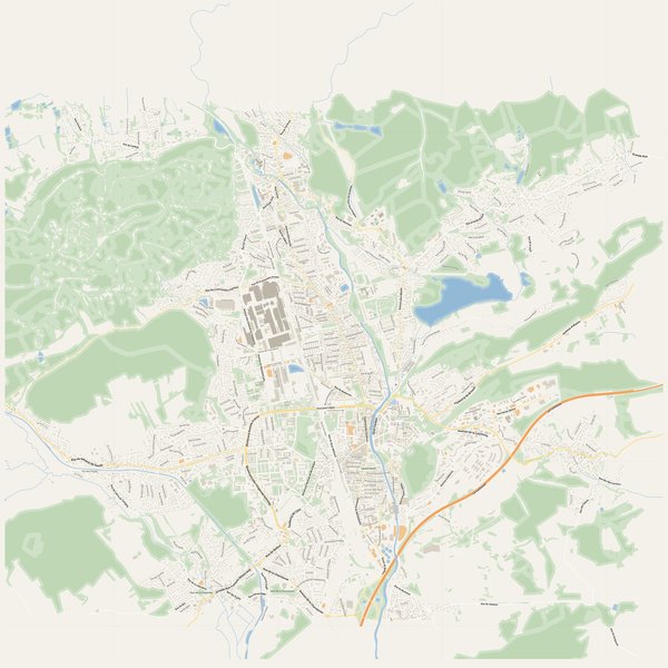
Large-format printable PDF maps of Belfort, France — every street with its name, every house number centred on its building, hospitals, schools and civic services. Vector PDF: print sharp at any size, from desk format to a wall poster.
Three printable PDF maps from the same OpenStreetMap data — pick the one for your use case. Single-file download, no subscription, vector quality at any print size.
FREE
Free city map
Every street with its name on a clean overview of the whole city. Good for orientation, route planning meetings, and as a base layer your team can mark up.
All streets, all street namesParks, water, civic landmarksNo house numbers — see the streets-with-numbers map for thoseVector PDF · scale 1 : 5 000 · paper sized to city extent
House numbers placed in the centre of every building, every street labelled. Pure address map — no clutter. For mailroom, courier, planning, surveying.
Every street + every house number (centred on building)No POI clutter — addresses speak for themselvesBuilding colour legend in footer (residential / hotel / shop / civic)Vector PDF · scale 1 : 5 000 · paper sized to city extent
The addresses map plus civic landmarks: hospitals, fire stations, police, universities, pharmacies. Built for office walls, dispatch rooms, planning departments.
Every street + every house numberHospitals, fire stations, police, universities, pharmacies markedDistinct shapes per category — readable in black & white photocopyVector PDF · scale 1 : 5 000 · paper sized to city extent
Real numbers from the OpenStreetMap data this map is rendered from.
1,042named streets
561km of streets
10,161house numbers
16,608buildings
2,548parks & green areas
Longest streets in Belfort
La Comtoise10.0 km
La Coulée Verte du Canal6.69 km
Rue Aristide Briand3.51 km
Rue du Général de Gaulle3.01 km
Grande Rue2.91 km
Rue de Danjoutin2.8 km
Civic services on the pro map
UniversitiesFaculté de Droit Léon Delarbre · Université de Franche-Comté - Sciences Techniques et Gestion de l'Industrie - Site de Belfort · AFPA-Production +7
PharmaciesPharmacie des Résidences Luxembourg · Pharmacie Engles · Pharmacie du Marché +7
KindergartensCentre de Loisirs maternel « La souris verte » · Koala kids · Crèche Municipale +2
SchoolsCollège privé Notre-Dame des Anges · Collège privé Sainte-Marie · Lycée général et technologique privé Notre-Dame des Anges +7
PolicePolice Municipale · Gendarmerie nationale · Police nationale +1
HospitalsCentre Hospitalier Spécialisé de Saint-Rémy et Nord Franche Comté - Centre de Psychiatrie Générale de Belfort · Clinique de la Miotte
ClinicsAmandine Riche & Julien Lallement
Fire stationsCentre de secours de Belfort-Nord
The Belfort map, printed
What you get and how it prints.
What size is the printed Belfort poster?
At the native scale of 1 : 5 000 the Belfort map measures about 174 × 122 cm. It is a vector PDF, so you can also print it smaller (A3, A2) or larger without any loss of sharpness.
What exactly is on the map?
1,042 named streets (561 km in total), 10,161 house numbers placed on their buildings, parks, rivers and civic landmarks — all from current OpenStreetMap data for Belfort.
What file formats do I get?
A vector PDF (prints sharp from A4 up to a 2-metre wall poster) and a large JPG preview. One file, instant download, no subscription.
Can I get a refund?
14-day refund, no questions asked. See our refund policy. →