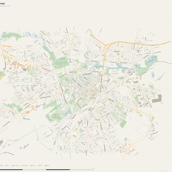
Large-format printable PDF maps of Arras, France — every street with its name, every house number centred on its building, hospitals, schools and civic services. Vector PDF: print sharp at any size, from desk format to a wall poster.
Three printable PDF maps from the same OpenStreetMap data — pick the one for your use case. Single-file download, no subscription, vector quality at any print size.
FREE
Free city map
Every street with its name on a clean overview of the whole city. Good for orientation, route planning meetings, and as a base layer your team can mark up.
All streets, all street namesParks, water, civic landmarksNo house numbers — see the streets-with-numbers map for thoseVector PDF · scale 1 : 5 000 · paper sized to city extent
House numbers placed in the centre of every building, every street labelled. Pure address map — no clutter. For mailroom, courier, planning, surveying.
Every street + every house number (centred on building)No POI clutter — addresses speak for themselvesBuilding colour legend in footer (residential / hotel / shop / civic)Vector PDF · scale 1 : 5 000 · paper sized to city extent
The addresses map plus civic landmarks: hospitals, fire stations, police, universities, pharmacies. Built for office walls, dispatch rooms, planning departments.
Every street + every house numberHospitals, fire stations, police, universities, pharmacies markedDistinct shapes per category — readable in black & white photocopyVector PDF · scale 1 : 5 000 · paper sized to city extent
Real numbers from the OpenStreetMap data this map is rendered from.
1,025named streets
532km of streets
9,425house numbers
27,723buildings
2,502parks & green areas
Longest streets in Arras
Avenue Winston Churchill5.25 km
Rocade Ouest d'Arras4.59 km
Rue de Cambrai2.84 km
Rue du 8 Mai 19452.23 km
Rue Raoul Briquet2.09 km
Avenue de l'Hippodrome2.05 km
Civic services on the pro map
PharmaciesPharmacie de l'Abbaye · Pharmacie des Blancs Monts · Pharmacie Les Hochettes +7
UniversitiesEPSI - L'école d'ingénierie informatique · Association pour la Formation, l'Expérimentation et la Recherche en Travail Educatif et Social · Institut de formation d'aides-soignants et auxiliaires de puériculture +7
SchoolsÉcole maternelle Lacorre-Rouquié · École maternelle Voltaire · Section d'enseignement général et professionnel adapté du Collège Adam de La Halle +7
KindergartensMicro-crèche · Multi accueil · Micro-crèche Pas à pas +7
HospitalsHôpital de jour · Centre hospitalier d'Arras · Clinique Aloïse Corbaz
ClinicsCentre Rnpc · Centre de Médecine du Sport · Maison de santé « Le Ryonval » +2
PolicePolice nationale · Police municipale · Gendarmerie nationale
Fire stationsCentre de secours principal d'Arras · Service départemental d'incendie et de secours du Pas-de-Calais
The Arras map, printed
What you get and how it prints.
What size is the printed Arras poster?
At the native scale of 1 : 5 000 the Arras map measures about 131 × 101 cm. It is a vector PDF, so you can also print it smaller (A3, A2) or larger without any loss of sharpness.
What exactly is on the map?
1,025 named streets (531 km in total), 9,425 house numbers placed on their buildings, parks, rivers and civic landmarks — all from current OpenStreetMap data for Arras.
What file formats do I get?
A vector PDF (prints sharp from A4 up to a 2-metre wall poster) and a large JPG preview. One file, instant download, no subscription.
Can I get a refund?
14-day refund, no questions asked. See our refund policy. →