Large-format printable PDF maps of Antony, France — every street with its name, every house number centred on its building, hospitals, schools and civic services. Vector PDF: print sharp at any size, from desk format to a wall poster.
Three printable PDF maps from the same OpenStreetMap data — pick the one for your use case. Single-file download, no subscription, vector quality at any print size.
FREE
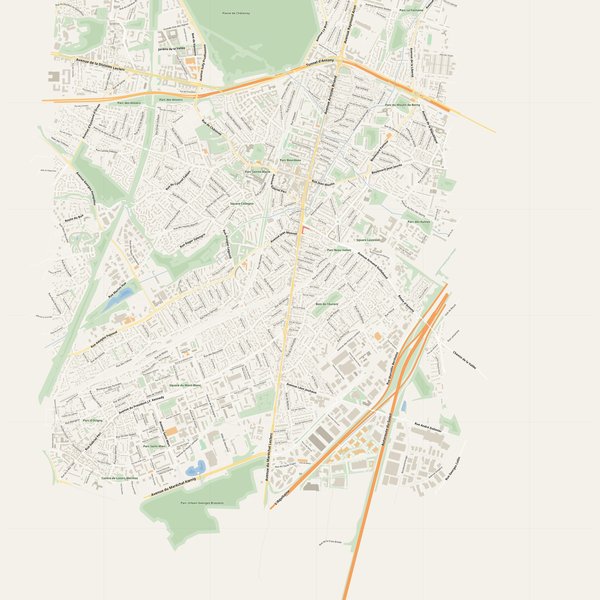
Free city map
Every street with its name on a clean overview of the whole city. Good for orientation, route planning meetings, and as a base layer your team can mark up.
All streets, all street namesParks, water, civic landmarksNo house numbers — see the streets-with-numbers map for thoseVector PDF · scale 1 : 5 000 · paper sized to city extent
House numbers placed in the centre of every building, every street labelled. Pure address map — no clutter. For mailroom, courier, planning, surveying.
Every street + every house number (centred on building)No POI clutter — addresses speak for themselvesBuilding colour legend in footer (residential / hotel / shop / civic)Vector PDF · scale 1 : 5 000 · paper sized to city extent
The addresses map plus civic landmarks: hospitals, fire stations, police, universities, pharmacies. Built for office walls, dispatch rooms, planning departments.
Every street + every house numberHospitals, fire stations, police, universities, pharmacies markedDistinct shapes per category — readable in black & white photocopyVector PDF · scale 1 : 5 000 · paper sized to city extent
Real numbers from the OpenStreetMap data this map is rendered from.
902named streets
419km of streets
4,773house numbers
17,409buildings
681parks & green areas
Longest streets in Antony
Autoroute du Soleil8.45 km
Avenue de la Division Leclerc6.74 km
La Coulée Verte4.7 km
L'Aquitaine4.69 km
Avenue Sully Prudhomme3.72 km
Avenue du Général de Gaulle3.22 km
Civic services on the pro map
SchoolsÉcole maternelle publique Jean Moulin · École Élémentaire Moulin-Pasteur · École Élémentaire Jean Moulin +7
PharmaciesPharmacie des Écoles · Pharmacie La Fontaine · Pharmacie CHAU VINH +7
PolicePolice nationale · Commisseriat de police minicipale
KindergartensCentre de loisirs Parc Heller · Crèche de la Peupleraie · Crèche Municipale Les Petits Princes +7
UniversitiesInstitut national supérieur du professorat et de l'éducation de Versailles (site Antony) · Collège provisoire Anne Franck · ISEN Paris - Institut supérieur de l'électronique et du numérique Yncréa +2
ClinicsCabinet médical et paramédical · Clinique l'Amandier · Olympe Santé
HospitalsHôpital privé Jacques Cartier · Établissement Public de Santé de Fresnes · Hôpital Psychiatrique Erasme +1
Fire stationsCentre de secours d'Antony
The Antony map, printed
What you get and how it prints.
What size is the printed Antony poster?
At the native scale of 1 : 5 000 the Antony map measures about 73 × 102 cm. It is a vector PDF, so you can also print it smaller (A3, A2) or larger without any loss of sharpness.
What exactly is on the map?
902 named streets (419 km in total), 4,773 house numbers placed on their buildings, parks, rivers and civic landmarks — all from current OpenStreetMap data for Antony.
What file formats do I get?
A vector PDF (prints sharp from A4 up to a 2-metre wall poster) and a large JPG preview. One file, instant download, no subscription.
Can I get a refund?
14-day refund, no questions asked. See our refund policy. →